Tag Archives: Jack Kerouac

Silence Is Golden

“The silence was an intense roar.”

-Jack Kerouac

IMG_6593_edited

One of the things that I like the most about hiking is that I have the ability (if I choose the right trail and time), to hike in almost perfect silence. Besides the wind blowing through the trees or the occasional chipmunk or squirrel running through the woods, most of the time I am fortunate to be able to walk in complete utter silence.

This is indeed a beautiful thing based on the fact that my days are spent in a high school surrounded by 1,600 students. Needless to say, my days are filled with varying degrees of talking, screaming, and laughter, all at a decibel that would rival a jumbo jet taking off. All that for almost seven hours a day.

So it is silence that I seek the end of the day, especially at this time of year. Students know that the end of the school year is just around the corner and obviously so do the teachers. Thoughts are on the end of the year exams, completing work (on time and late), and just the frenzied free for all that all teachers call “the end of the year.”

So it is the time when the students walk out the door for the last time and the teachers are soon to follow that we each choose our destination and activity to recharge the batteries and regain the Zen needed to make it through another year.

I know, boo hoo for the poor teachers who have the entire summer off! All of that aside, we all should have a place where we can go and know that for even a short period of time nothing is able to disturb us so we can regain our sanity!

HAPPY HIKING!!!

Back On The Trail!!!

“I had nothing to offer anybody except my own confusion.”

-Jack Kerouac

IMG_4561

If every morning could be like this morning, hiking would always be easy and life would be perfect. With clear blue skies and a starting temperature of 48 degrees, it was a beautiful morning to get out into the woods for a hike.

Since this is only my third hike since my surgery, I’m still keeping things kind of slow and trying to stay on trails that I know aren’t that difficult. So at around 5:30 am I headed out to Ward Pound Ridge. With a Phish show from 12/29/18 playing on the Jeep’s stereo, all was right with the world.

All told I hiked 5.1 miles this morning. I think that once I can get out more often than I

am now, my legs and feet won’t hurt as much as they did. They know as well as I do that they haven’t been out in the woods for a loooong time. But that’s ok. I’ve got between now and the summer break and then two glorious months to try and get out every day.

HAPPY HIKING!!!

2019 Mileage:

Hike#3-5/11-5.1-12

The Trail Keeps Calling

“I felt like lying down by the side of the trail and remembering it all. The woods do that to you…”

-Jack Kerouac

Although it wasn’t sunny out, the temperature and humidity today were much lower than on Saturday.  Starting at almost the same time, the improved weather made the hiking much easier on the mind as well as the body. As always, it was a great hike and an awesome way to start the day!

IMG_6555_edited

IMG_6554_edited

Happy Hiking!!!

Hike #15-8.0-90.3

It’s About Time!

“Because in the end, you won’t remember the time you spent working in an office or mowing the lawn. Climb that goddamn mountain.”

– Jack Kerouac

All week long the weather folks have been promising us that we were in store for a beautiful day today. With temps in the high 60’s, it hasn’t been this nice in a long, long time. After a winter of nor’easters, snow and freezing rain, I firmly believe that we were owed a day like today. Ignore the fact that tomorrow the high is supposed to be 38 and they are saying we might get some sleet, I’ll take a day like today anytime I can.

Starting at just around 6:20 am, the temperature was an incredible 52 degrees and the sky was devoid of any clouds. There is really nothing I can say to describe just how glorious it was! I can’t think of to many other things I would have rather been doing this morning.

IMG_6400 (2)

My first critter sighting of the new hiking season. He came within a half of a step of going to froggy heaven.

IMG_6398 (2)

My new friend giving me the peace sign after not losing his life.

IMG_6401 (2)

My trusty pack and poles resting on one of the rocks where I take breaks.

Happy Hiking!!!

Hike #3-7.1-16.3


Is It Really Fall?

“The silence was an intense roar.”

-Jack Kerouac

“Rocks are space, and space is illusion,”

-Jack Kerouac

You would think that on September 26th I would be reporting to you that I was hiking in nice cool temperatures in the 60’s. No such luck. At 4:20 pm today it was 86 degrees with a “real feel” of 91. Wow! Where did fall go? Even with the high temps and incredibly oppressive humidity, it was still worth getting out.

I will say that because it was so hot, I cut down the mileage of my hike to 3.6 miles, went considerably slower than I usually do and took several water breaks. To keep things simple, I just did the Green Trail at Ward Pound Ridge Reservation.

The picture below is the same camera shot from the other day when I posted the sunrise. What a difference!

WP_20170926_006

A beautiful but hot day at Ward Pound Ridge.

WP_20170926_008

I stopped by this huge rock to drink some water!

WP_20170926_009

The trail after a water break.

Happy Hiking!!!

2017 Mileage:

9/26/17-3.6-244.82

Ward Pound Ridge Reservation-Brown Trail (20)

“The closer you get to real matter, rock air fire and wood, boy, the more spiritual the world is.” 
―Jack Kerouac

“I felt like lying down by the side of the trail and remembering it all” 
―Jack Kerouac


***With this hike I finally went over 100 miles for the summer. Woo Hoo!!!! Hopefully no more rain!

Just the other day I ventured onto the Blue Trail on the Ward Pound Ridge Reservation. I chose to tackle the trail in a counterclockwise manner and I am glad that I did. Although the trail was pretty steep at the beginning and had several demanding climbs and even more demanding descents, the last section of the trail was relatively flat.  To get a better idea of the rest of the trails in the park, I purchased Walkable Westchester by Jane and Walt Daniels. This book gives detailed descriptions of trails in the parks in Westchester County, NY.

Parking in the Kimberly Bridge parking area again, you actually stay on the parking lot side of the road to access the Brown Trail. Starting off on the DH trail, you follow that until it intersects with the Brown Trail.

81317001

The Cross River just off of the Kimberly Bridge parking area.

81317002

The DH Trail as it re-enters the woods. Shortly you will veer right onto the Brown Trail.

As you begin hiking on the Brown Trail, it ascends quickly and steeply for a short time. As with the blue trail, unless you are looking for a hike with what seems like never ending climbing, you should do this in a counterclockwise direction.

81317003

The Brown Trail moving to the right.

After climbing, leveling off and then descending, the trail turns sharply to the left and with the exception of a very short climb, stays level or moves downhill for the rest of the hike.

81317004

The hiking was easy on this portion of the trail. 

81317005

The Brown and the DH Trail stay together for a short time. 

One of the more interesting things about this hike is the varied terrain that you come across. Woods roads, forest, Cross River and now an almost tunnel like experience as you hike through this portion of the trail.

81317006

81317008

A bridge connecting the Brown Trail with the FH Trail. 

81317010

The Cross River again, this time deeper in the woods.

After completing the Brown Trail Loop, I crossed the street and hiked some more on the DH Trail until it came to Reservation Road. At this point I turned left and headed back to the parking area.

Happy Hiking!!!

Summer 2017 Mileage:

8/13/17-5.1-101.32  


Skunk + Bear = One Very Interesting Hike


IMG_9317

“I’ll call if I break a leg or get eaten by a bear.”
“Play like a rock.”
“Now?”
“No, if a bear starts eating you.”
I thought for a moment before replying. “Do they have screaming, sobbing rocks, ’cause that’s probably what I’ll be doing if a bear is gnawing my arm off.”
“It would be difficult to just lay there and be eaten alive, huh?”
“Ya think?”
― Darynda Jones

Well folks, without a doubt, today’s adventure will be in The Zen Hiker’s top two or three hikes of all time. After looking at the weather and seeing a forecast for severe storms later in the day, I decided to get out really early to beat the storms as well as the heat. Leaving my house at 4:00 am, I got to the parking lot at the Bear Mt. Inn at about 4:45. Even though it was cooler than previous mornings, the humidity was still oppressive enough where walking across the field to the trail had me sweating.

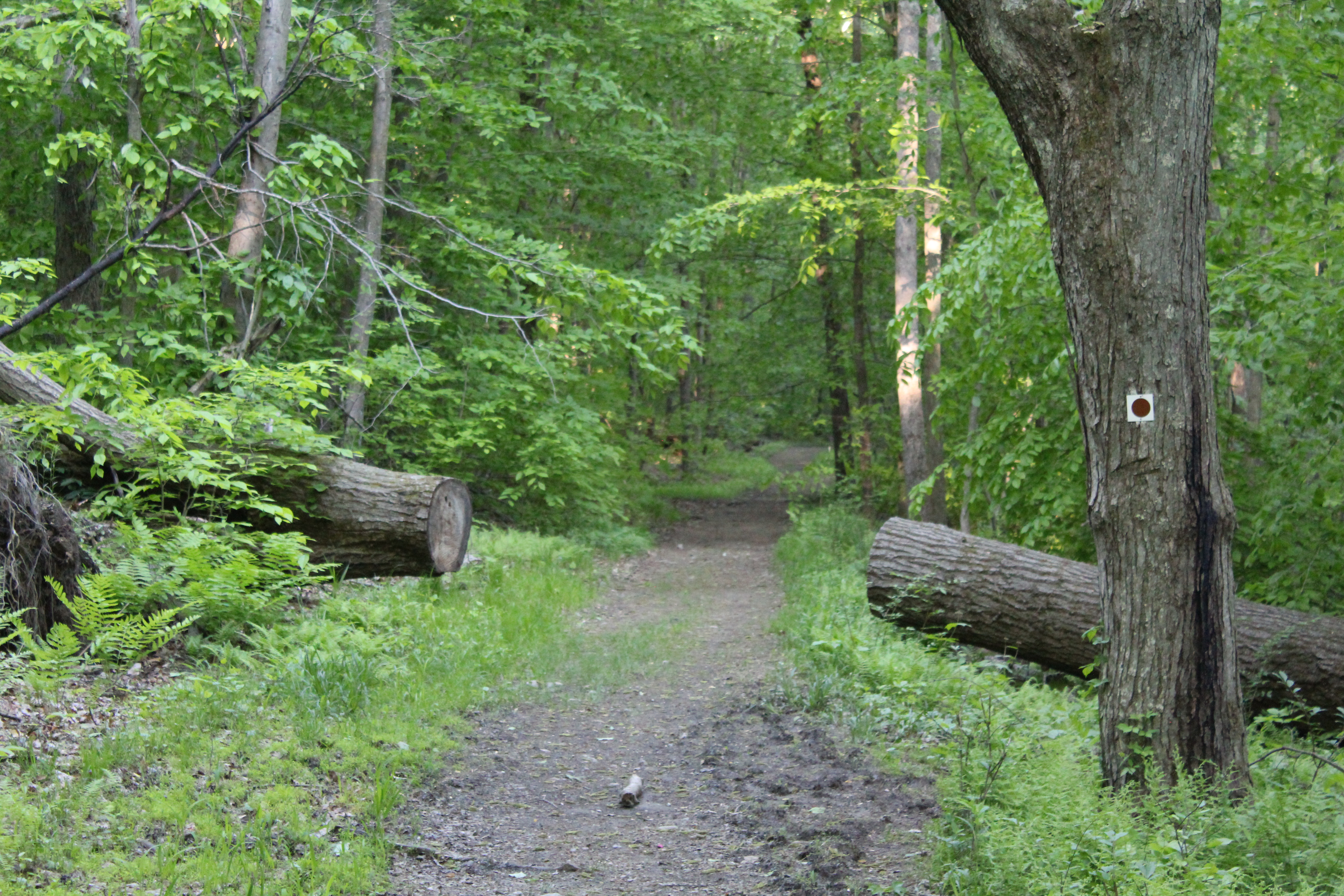
Now before I get into why this will rank in the top hikes I have ever done, I have tell you that the work that has been done rerouting the AT from the Bear Mt. Inn to the road (about 3/4 of the way up) is phenomenal. At Hessian Lake they have added a section that is almost like a tutorial for people who may be new to hiking. As you walk through this miniature AT, an old stone building stands guard as you make your way towards the rerouted section that leads to Perkins Memorial Tower.


IMG_9405

IMG_9404

IMG_9403

Bizarre encounter #1- I will call it-“Seriously? A skunk?”

As I  walked along the edge of the building, the only sound I could hear was my boots scuffing the ground and the click clack of my hiking poles. Approaching the end of the building, I was getting myself mentally ready for the next two miles that I knew were going to be totally up hill. Without warning, and providing enough of a scare that a string of expletives flew from my lips, a skunk of enormous proportions waddled around the corner. Now if the skunk could have screamed, I am positive that it would have.

IMG_9406

To the right of this beautiful old stone building was were the skunk and I had our brief but memorable encounter.

Instead, unintentionally and without malice, I happened to be so close to Mr. Skunk that I kicked it right in the head, scaring the crap out of me as well as my new friend. Obviously luck was with me because as I took off running in one direction, the skunk took off in the other. When I stopped running, my mind was racing because I thought for sure that I had been sprayed and that at any second the not so pleasant odor of skunk would overwhelm me. For whatever reason, be it the shock of the surprise of literally running into each other or just dumb luck, I had been spared the horror and discomfort of the skunks primary defense system. Heading up the trail, thankfully the only somewhat bad odor that I noticed was me.

The work done by the trail crews is really unbelievable. Carefully manicured, the trail led to stone steps that quickly and steeply zig zagged its way up the side of the mountain.

IMG_9401

IMG_9400

IMG_9398

The wonderful thing about the trail now is that although the climb is steep, the space between each step is just about perfect and after each climb, the trail levels off for a period to give you a chance to recover.

IMG_9393

IMG_9384

IMG_9396

One of the things that I wanted to make sure that I captured on this hike was the sun rising from other side of the Hudson. For once, you will be able to see the nose from Bear Mt., instead of the other way around. Something new!

IMG_9334

Anthony’s Nose as seen from Bear Mt.

IMG_9333

Bear Mt. Bridge and Anthony’s Nose

IMG_9335

The morning sky 

IMG_9344

The whole reason for doing this hike was to get to Perkins Memorial Tower. On any weekend day during the summer (and some weekdays as well), this entire area will be filled with people. Cars fill each parking spot, hikers appear and disappear from the myriad of trails that intersect in and around the area of the tower and the level of solitude is zero. I would not recommend this hike if peace and quiet are what you are looking for.

IMG_9339

Perkins Memorial Tower at Bear Mt. Elevation 1284 feet

IMG_9347

Bizarre animal encounter #2 which I will call-“Is he really coming after me?”

Ok. Now for more fun stuff. As I was returning back to the Inn on the AT, part of the trail goes down a stretch of road. Since it was still early, the only sounds I could hear were the Metro North trains ferrying the sad masses to the city to their jobs. Shortly after coming out of the woods and onto the road, I heard clapping and yelling. My first thought was BEAR! Since the commotion was coming from the direction I was headed, I slowed down and kept my eyes on the woods. No more than a couple of minutes passed when I looked to my left and saw this:

IMG_9367

IMG_9368

Granted, this may not have been the biggest bear, but it was a bear nonetheless. Now, in my many years of hiking, I have encountered probably every other type of animal you would expect to see. I have even seen numerous rattlesnakes! But I have never, ever encountered a bear. Not until today. As I snapped the pictures above, I was happy because the bear seemed spooked and was moving away from me. To keep him hopefully heading in a direction away from me, I put my camera away and slowly made my way down the trail. As I did, I noticed my second new friend of the day turn and head directly to where I was walking.

IMG_9364

He found his way up to the road and started following  me. Needless to say, I wasn’t that thrilled to have a bear stalking me. Of course my mind was now racing again with thoughts on what I would do if he actually came after me. Do I lay down and play dead? Do I yell and make noise like the guy I heard just a few minutes ago? (Obviously whatever he did had him moving directly towards me.) Do I run for my life and hope that he isn’t that hungry? I wasn’t really sure. All I knew was I would rather almost step on another rattlesnake instead of deal with this guy! Luck was with me again as the bizarre cat and mouse game only went on for about fifteen minutes before he turned into the woods again and headed towards the tower.

Was I really that nervous when I initially saw the bear? Not really. My trepidation came when I thought that he had decided to turn me into his next meal. Of course as I think about it now, that probably wouldn’t have happened, but at the time, I was picturing myself being seasoned by my furry friend. Time to get some pepper spray.

IMG_9329

IMG_9358

Looking north on a hazy morning.

Happy hiking everyone!!!!


For Your Viewing and Hiking Pleasure-The Cornell Mine Trail->Bald Mountain

“The mountains are calling and I must go.”
-John Muir
“Because in the end, you won’t remember the time you spent working in the office or mowing your lawn. Climb that goddamn mountain.
-Jack Kerouac
IMG_8520
My love hiking in the Hudson Valley is well documented. One of the things that you will learn about hiking here, however, is that many of the hikes in this area start with a long, lung busting and thigh searing climb. This is a given. Some of them happen to be mildly torturous  and some of them make you wonder why you are hiking there in the first place. But remember, with these sometimes murderous climbs (perception is everything), the payoff of a magnificent view makes it all worthwhile.
My friend Jaime and I decided to meet pretty early on the 4th to do a hike in Bear Mt. A nice loop in the area is the Cornell Mine Trail to Bald Mt. and then down and out through Doodletown on Pleasant Valley Road. Parking proved to be pretty easy as we both found space to park just across from the trail head and around 50 yards from the entrance to Iona Island.
IMG_8623
IMG_8532

The Bear Mt. Bridge as seen from sea level at the parking area on Route 9W.

IMG_8531IMG_8517
As you cross 9W and enter the woods, the trail immediately turns to the left and then you begin a relatively steep climb. Don’t worry, because after about ten minutes, the trail levels off and you are able to catch your breath as you continue to move steadily towards the most serious climb of the day.
IMG_8536

Jaime on the Cornell Mine Trail-I’ve been hiking with this guy for over twenty years!!!
IMG_8539


IMG_8541
As you hike towards Bald Mt., you will notice that the terrain is pretty diverse in regards to what it has to offer. At one point you may be hiking on what appears to be a well manicured trail, and on others you will have to keep your eyes on the ground in front of you due to large amount of loose rocks laid out in front of you.
After a little more than a half an hour of hiking, you’ll notice the huge and imposing figure of Bald Mt. directly ahead of you. Even though it looks much more imposing during the winter months when the trees have no leaves, even now you certainly know that it is there, waiting for you. Trust me, it is going to suck the life out of you if you let it! As you approach this part of the climb, it appears relatively flat. Don’t be fooled by this because the most challenging part of the climb awaits you. The trail quickly begins a steep and unrelenting climb up to the view-point. To ease the pain, you will find some switchbacks on the first part of the climb that offer a modicum of relief. Remember that you will be climbing a vertical distance of 500 feet in less than half a mile.
A quick word of caution to all hikers regardless of experience-The footing on this, the most difficult part of the hike, is pretty treacherous. Please be very careful based on the fact that loose dirt and rocks combine to make for what could be a bone busting experience!
After you have climbed about 80% of the mountain, the trail will take a very sharp left. Before you head up and finish the Cornell Mine Trail, turn around for a stunning view of the Bear Mt. Bridge.
IMG_8548
IMG_8549
After soaking in the view and taking a well earned rest, turn back around continue to head the trail. In just a few minutes, The Cornell Mine Trail ends at a junction with the Ramapo-Dunderberg Trail. Make sure that you turn right onto the Ramapo-Dunderberg Trail and continue climbing. Although you are still moving up, it is nowhere near the intensity of the rest of the climb. After leaving the intersection, you should reach the summit of Bald Mt. (Elevation 1,080 feet), in about ten minutes. As you get closer, you will continue straight ahead on an unmarked path to reach the summit. At this point you will have climbed more than 1,000 vertical feet from the start of the hike on route 9W to the summit.


Even though there was some haze in the air, the views were magnificent and I believe that I was able to get some good pictures. To give you some perspective, Anthony’s Nose is the mound on the right side of the bridge.

IMG_8550

Bear Mt Bridge with Anthony’s Nose to the right.

IMG_8551

Bear Mt. Please note the tower about 3/4 from the right.

IMG_8558

Perkins Memorial Tower as seen from Bald Mt.


IMG_8563

IMG_8564

After relaxing for a while, you can take the red on white trail markers on your right and start heading down. Once again, the trail down has some pretty loose dirt and rocks and  with the first descent being quite steep, you might want to be more cautious than you normally would be. After a brief leveling off, you continue heading down the trail, eventually coming to an almost tunnel of Mt. Laurel.

IMG_8565

When you reach the stream, you will make a quick right turn and shortly after that the Ramapo Dunderberg trail continues to the left. For our purposes, we decided that instead of heading to the Timp, we would continue down on a woods road into Doodletown. This woods road soon becomes the 1777 trail.

IMG_8569

As you come down a final small hill, the trail levels off and crosses a stream. To the right, stone foundations and a trail shelter can be seen. You have to make sure that you look quickly because if you aren’t paying attention, you may miss the shelter!

IMG_8567

IMG_8572

As you continue ahead on the woods road, you will soon enter and move through the former settlement of Doodletown. This settlement thrived in this area for two centuries until it was acquired by the park in around 1960. But before you get to Doodletown, keep looking around to make sure that you don’t miss these views.

IMG_8614

IMG_8615

This sign below represents a walking tour sign to help guide you through the area.

IMG_8606

At this point you will have been walking on paved roads and will continue to do so until the hike ends.

IMG_8593

A stone wall from one of the many houses at Doodletown.

IMG_8595

We kept hiking along the 1777 Trail, which is also known as Pleasant Valley Road, and as you make your way down the road, you will pass the remnants of the many homes that formed Doodletown. You will see markers like this all along the trail to show where each of the houses in the settlement were located.

IMG_8579

One of the more interesting sights that you can see in the Doodletown settlement is the remnants of their garbage. Apparently they used to bury their garbage and from time to time, you can see garbage that has “floated” to the top through erosion of the land. A good example is this broken milk bottle:

IMG_8596

 Shortly after I took this picture, the grade of the road dipped steeply and we were back on Route 9W where we started. This is the last sign you will see as you finish the hike and If you decide to do this hike in reverse, it will be the first.
IMG_8621 (1)
The hike ended up being about 5 1/2 miles with just over 1,000 ft in elevation gain. With stopping to rest and taking pictures, it took us about 3 1/2 to complete. Based on its level of difficulty as well as numerous viewpoints and other worthy sights, this is definitely a hike you don’t want to rush through. Take your time to soak it all in, it’s worth it!
Now, with all of that said, although I would never discourage anyone from taking a hike, if you want to take animals small kids on this one, you need to be really careful.The steepness of the climb as well the loose dirt and rock on the climb could prove to be too much for a smaller child or a dog.
Any adults, however, who want to do this hike, I say GO FOR IT!!!!!