Author Archives: Freedom Hiker

Unknown's avatar

About Freedom Hiker

I served in the USMC directly out of high school and then taught for two years in the Bronx, NY. I was then a Special Education Coordinator/Special Education teacher at a public high school in the Lower Hudson Valley in Westchester County, New York, for over 20 years. Although I love going to Anthony's Nose, I try to get to different spots in the area. One great thing about living in the Hudson Valley is the abundance of great hikes. You can do the same hike in different seasons, and it will be as if you were hiking that trail for the first time. It doesn't get much better than that!

Another Great Hike-Stockbridge Mountain and Lake Nawahunta

IMG_8644

Before I even begin to fill you in about the awesome hike that I did today (7/7/16), I really need to address this sign. I encountered this “ICE” sign about 1/2 of a mile down the road from the Silver Mine Picnic Area. Even though it was only a short distance into my hike, by the time I looked up and saw the sign in front of me, I was already bathed in sweat and as I always do when it is this hot and humid, I wonder, often times out loud, “WTF am I doing??” But I couldn’t help but laugh out loud as I thought about the absurdity of having an ICE sign be the first thing that you would see on today’s post. When I began hiking at 7:20 am, the temperature was already in the mid  70’s with humidity near 90%.

Ok. With that out of the way, I was on Amazon a few days ago and I saw and eventually bought a book called “Circuit Hikes in Harriman-35 Loop Hikes and Trail Runs in Harriman and Bear Mountain State Parks” by Don Weise. Even though I have the trail maps associated with both Northern and Southern Harriman and Bear Mountain, it is sometimes difficult to figure out distances, elevations and other pertinent information  you might want to know when you are planning a hike. So if you hike by yourself or don’t want to do a two car hike, this is the book for you!

As I flipped through the book, I immediately liked the way that the author has each hike laid out. Each one is a chapter of the book and has all of the  information that would need to plan a hike. With each hike you get a rating, distance, hiking time, attractions, lowest elevation, highest elevation, total elevation gain, parking GPS coordinates and what map is associated with the hike.

After the 4th of July lung buster , I thought that for today’s hike I would look for something in the easy to moderate range (the author’s method of describing each hike).  I settled on the Stockbridge Mountain and Lake Nawahunta Hike (Weise 87-91). With a distance of 5.2 miles, a total elevation gain of 990 feet and a difficulty rating of easy to moderate, this would be the perfect way to start the day (87).

Parking at the Silver Mine Picnic Area, I found the Menomine Trail (yellow Blaze) and headed out on the trail.

IMG_8635

IMG_8646


Even at the picnic area, you should take some time to just look around and take in the view.

IMG_8633

IMG_8630

IMG_8639

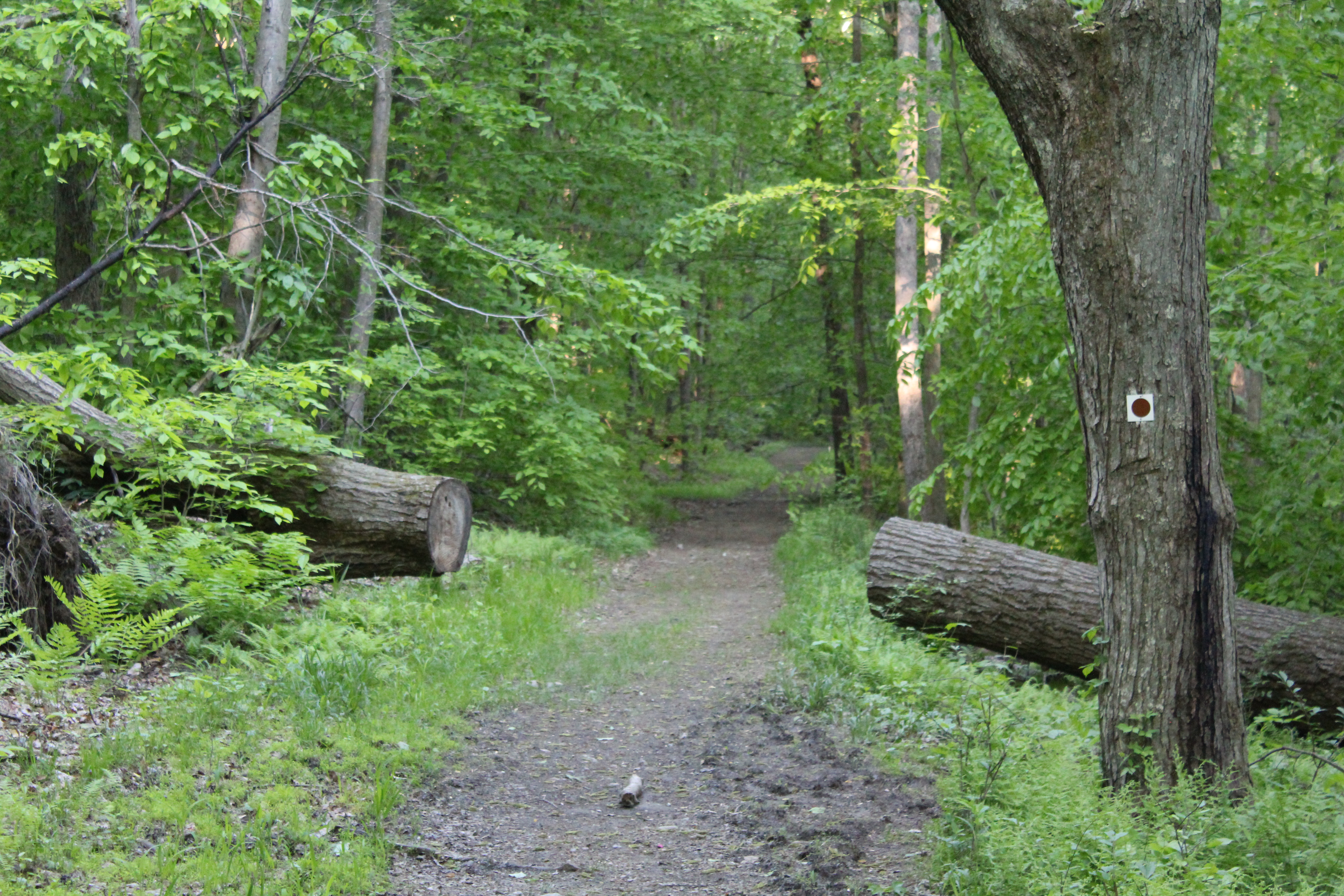
Running parallel to Seven Lakes Drive, the trail quickly crosses the road and becomes an idyllic earthen trail covered in pine needles. You wouldn’t think that in July  you would be overcome by the smell of the pine needles, but this was certainly the case today. It was truly intoxicating!

IMG_8647

IMG_8651

As you move steadily along the trail, look to your left and you will see Lake Nawahunta.

IMG_8650

IMG_8691

I can’t explain the feeling of the soft earth under your feet as you move through the woods. The sounds of birds filled the air as well as the chipmunks searching for food, often times surprised by the sound of my boots hitting the ground forced them to scramble for cover.

Shortly after you pass the lake, you will see the Menomine Trail veer off to the left and an unmarked woods road heading up and to the right (you will return and finish the hike this way). You are going to take the unmarked woods road. Don’t worry, even though it is not marked, you can’t possibly get lost or wander off of the trail.

IMG_8652

The hiking is pretty easy as you proceed along the trail. Very slight ups and downs provide you with a sense that you are gaining elevation, but not so steeply that you can’t enjoy everything that is going on around you on the trail.

IMG_8653

IMG_8654

IMG_8655

IMG_8656

IMG_8658

Just about 1.8 miles into the hike, the unmarked woods road intersects with the Long Path. If you are hiking with small children or are looking for a relatively easy 4 mile hike, turn around here and head back the way that you came. If you are going to continue on for the next 3 miles, turn left and follow these aqua blue blazes:

IMG_8659

One thing that you will notice as you make the left turn on to the Long Path is the ground becomes much more rocky than the previous 2 miles.

IMG_8661

IMG_8662

IMG_8663

IMG_8664

Even though the climb itself is not that steep, from the time that you turn onto the Long Path, you find yourself heading uphill. With the humidity as high as it was, I took the opportunity to stop several times to drink water so I wouldn’t get dehydrated.

IMG_8668

Looking back down the trail as I take a water break.

IMG_8669

Still some more climbing ahead!


IMG_8672

The climb comes to an end and three miles into the hike you will come across one of the most interesting sights in the entire park. The Stockbridge Cave Shelter (see photos below) has a fireplace and plenty of space for several people to sleep. Upon inspection, it is obvious that it is well used, but with that said, there was no litter and that was actually nice to see for a change.

IMG_8673

IMG_8674

IMG_8677

Check out the chair made out of a tree. It was a lot more comfortable than I thought it would have been!!!

After hanging out at the shelter for a bit, I took the trail up to the right of the shelter. Seeing the initial steepness of this climb, I originally thought that I was in for more of the same of what I had just experienced.

IMG_8678

This was not to be the case and as I crested the top I was happy to see the terrain level off as I continued towards my destination.

IMG_8679

After passing the Stockbridge Shelter, the trail heads steeply downhill and intersects with the Menomine Trail. This is the yellow trail you started on and it will take you all of the way back to your car in the Silver Mine Picnic Area.

IMG_8683

IMG_8684

The end of the Menomine Trail. Follow this trail all of the way back to where you began your hike!


IMG_8686

As I approached the lake, the overwhelming smell of pine took over took my senses once again and as I stopped to take a picture, I stood and took several deep breaths. Closing my eyes, all I could imagine was setting up a tent and hanging out for a couple of days!! Unfortunately, this spot, as incredible as I think it is, was just to close to civilization for my liking.

IMG_8687

IMG_8688

IMG_8690

Shortly after passing the spot in the picture above, I was back on Seven Lakes Drive heading back to my car. As I slowly walked on the side of the road, now totally dripping wet from sweat, I thought about Don Weise’s book and found the information in it to be spot on. If I still had younger kids I would definitely take them on this hike and remember, you can make this shorter if you need to for whatever reason.

A big thumbs up for the Stockbridge Mountain and Lake Nawahunta hike!!!!!!

For Your Viewing and Hiking Pleasure-The Cornell Mine Trail->Bald Mountain

“The mountains are calling and I must go.”
-John Muir
“Because in the end, you won’t remember the time you spent working in the office or mowing your lawn. Climb that goddamn mountain.
-Jack Kerouac
IMG_8520
My love hiking in the Hudson Valley is well documented. One of the things that you will learn about hiking here, however, is that many of the hikes in this area start with a long, lung busting and thigh searing climb. This is a given. Some of them happen to be mildly torturous  and some of them make you wonder why you are hiking there in the first place. But remember, with these sometimes murderous climbs (perception is everything), the payoff of a magnificent view makes it all worthwhile.
My friend Jaime and I decided to meet pretty early on the 4th to do a hike in Bear Mt. A nice loop in the area is the Cornell Mine Trail to Bald Mt. and then down and out through Doodletown on Pleasant Valley Road. Parking proved to be pretty easy as we both found space to park just across from the trail head and around 50 yards from the entrance to Iona Island.
IMG_8623
IMG_8532

The Bear Mt. Bridge as seen from sea level at the parking area on Route 9W.

IMG_8531IMG_8517
As you cross 9W and enter the woods, the trail immediately turns to the left and then you begin a relatively steep climb. Don’t worry, because after about ten minutes, the trail levels off and you are able to catch your breath as you continue to move steadily towards the most serious climb of the day.
IMG_8536

Jaime on the Cornell Mine Trail-I’ve been hiking with this guy for over twenty years!!!
IMG_8539


IMG_8541
As you hike towards Bald Mt., you will notice that the terrain is pretty diverse in regards to what it has to offer. At one point you may be hiking on what appears to be a well manicured trail, and on others you will have to keep your eyes on the ground in front of you due to large amount of loose rocks laid out in front of you.
After a little more than a half an hour of hiking, you’ll notice the huge and imposing figure of Bald Mt. directly ahead of you. Even though it looks much more imposing during the winter months when the trees have no leaves, even now you certainly know that it is there, waiting for you. Trust me, it is going to suck the life out of you if you let it! As you approach this part of the climb, it appears relatively flat. Don’t be fooled by this because the most challenging part of the climb awaits you. The trail quickly begins a steep and unrelenting climb up to the view-point. To ease the pain, you will find some switchbacks on the first part of the climb that offer a modicum of relief. Remember that you will be climbing a vertical distance of 500 feet in less than half a mile.
A quick word of caution to all hikers regardless of experience-The footing on this, the most difficult part of the hike, is pretty treacherous. Please be very careful based on the fact that loose dirt and rocks combine to make for what could be a bone busting experience!
After you have climbed about 80% of the mountain, the trail will take a very sharp left. Before you head up and finish the Cornell Mine Trail, turn around for a stunning view of the Bear Mt. Bridge.
IMG_8548
IMG_8549
After soaking in the view and taking a well earned rest, turn back around continue to head the trail. In just a few minutes, The Cornell Mine Trail ends at a junction with the Ramapo-Dunderberg Trail. Make sure that you turn right onto the Ramapo-Dunderberg Trail and continue climbing. Although you are still moving up, it is nowhere near the intensity of the rest of the climb. After leaving the intersection, you should reach the summit of Bald Mt. (Elevation 1,080 feet), in about ten minutes. As you get closer, you will continue straight ahead on an unmarked path to reach the summit. At this point you will have climbed more than 1,000 vertical feet from the start of the hike on route 9W to the summit.


Even though there was some haze in the air, the views were magnificent and I believe that I was able to get some good pictures. To give you some perspective, Anthony’s Nose is the mound on the right side of the bridge.

IMG_8550

Bear Mt Bridge with Anthony’s Nose to the right.

IMG_8551

Bear Mt. Please note the tower about 3/4 from the right.

IMG_8558

Perkins Memorial Tower as seen from Bald Mt.


IMG_8563

IMG_8564

After relaxing for a while, you can take the red on white trail markers on your right and start heading down. Once again, the trail down has some pretty loose dirt and rocks and  with the first descent being quite steep, you might want to be more cautious than you normally would be. After a brief leveling off, you continue heading down the trail, eventually coming to an almost tunnel of Mt. Laurel.

IMG_8565

When you reach the stream, you will make a quick right turn and shortly after that the Ramapo Dunderberg trail continues to the left. For our purposes, we decided that instead of heading to the Timp, we would continue down on a woods road into Doodletown. This woods road soon becomes the 1777 trail.

IMG_8569

As you come down a final small hill, the trail levels off and crosses a stream. To the right, stone foundations and a trail shelter can be seen. You have to make sure that you look quickly because if you aren’t paying attention, you may miss the shelter!

IMG_8567

IMG_8572

As you continue ahead on the woods road, you will soon enter and move through the former settlement of Doodletown. This settlement thrived in this area for two centuries until it was acquired by the park in around 1960. But before you get to Doodletown, keep looking around to make sure that you don’t miss these views.

IMG_8614

IMG_8615

This sign below represents a walking tour sign to help guide you through the area.

IMG_8606

At this point you will have been walking on paved roads and will continue to do so until the hike ends.

IMG_8593

A stone wall from one of the many houses at Doodletown.

IMG_8595

We kept hiking along the 1777 Trail, which is also known as Pleasant Valley Road, and as you make your way down the road, you will pass the remnants of the many homes that formed Doodletown. You will see markers like this all along the trail to show where each of the houses in the settlement were located.

IMG_8579

One of the more interesting sights that you can see in the Doodletown settlement is the remnants of their garbage. Apparently they used to bury their garbage and from time to time, you can see garbage that has “floated” to the top through erosion of the land. A good example is this broken milk bottle:

IMG_8596

 Shortly after I took this picture, the grade of the road dipped steeply and we were back on Route 9W where we started. This is the last sign you will see as you finish the hike and If you decide to do this hike in reverse, it will be the first.
IMG_8621 (1)
The hike ended up being about 5 1/2 miles with just over 1,000 ft in elevation gain. With stopping to rest and taking pictures, it took us about 3 1/2 to complete. Based on its level of difficulty as well as numerous viewpoints and other worthy sights, this is definitely a hike you don’t want to rush through. Take your time to soak it all in, it’s worth it!
Now, with all of that said, although I would never discourage anyone from taking a hike, if you want to take animals small kids on this one, you need to be really careful.The steepness of the climb as well the loose dirt and rock on the climb could prove to be too much for a smaller child or a dog.
Any adults, however, who want to do this hike, I say GO FOR IT!!!!!

It’s always better to be safe than sorry…

Now that I am getting older (not that old), I actually plan for emergency situations during even my most routine hikes. When I was younger, the thought of carrying a first aid kit with me never entered my mind. If I got a cut or twisted an ankle, I took 500 mg of suck it up and dealt with it when I finished the hike.

These days, I do have to admit that I have a little bit of a fear that if something happens to me while I am hiking, I might have to spend the night in the woods. For a situation like this, I believe that I am prepared if this does happen.

A good way to prevent spending a potentially long, cold and painful night in the woods from happening is to think proactively. First and foremost,  you should write an itinerary of where you will be hiking. I always leave a written record of where I will be parking, the route I will be taking and how long I think my hike will take. If I think that I am going to go over the time that I allotted, I text that person and let them know that. Of course getting a cell phone signal at times can be challenging out in the woods, but at some point you will get one. Regardless of your age, I strongly suggest that everyone do this. Many people have spent days in the woods and elsewhere because no one knew where they were. Case in point-Aron Ralston.

Here is what I currently carry in my daypack:

IMG_8514

Starting from left to right on the top:

  1. A Back Country First Aid Book. It covers care for every conceivable ailment or injury that you could incur out in the woods.
  2. A small shelter (space blanket) that will offer protection in the rain, wind, snow and the chill of the night if you are caught outside even in the summer.
  3. Along with a lighter, I carry waterproof matches.
  4. Of course bug spay.
  5. A small pouch that has gauze pads, band aids, Povidone-Iodine U. S. P. Prep Pads and antiseptic towelettes.
  6. The package marked Bandaging Materials has many of the same things as the red pouch, just in larger sizes.
  7. Pain relieving antiseptic spray.

Now this doesn’t seem like much, but for most of the minor to moderate things that can happen to you during a hike, I am more than prepared to deal with them. Especially if I am hiking with smaller children, a bee sting or bug bite can be made more comfortable until they get home! I keep all of these items in large baggies to make sure that they stay dry and all of this doesn’t take up much room in my pack. That leaves plenty of space for water, snacks, my camera, ipod, etc.

Finally, I did purchase two first aid kits off of Amazon for my daypack. If you do a  little research on the web, you can certainly make your own First Aid Kit by going to your local pharmacy or grocery store and buying everything that you need there. This is what I have done to replenish the items that I have used.

If you have any suggestions or would like to share what you currently use, please do so. Let’s learn from each other!!!!

Mt. Beacon-(Don’t Be Afraid)

Even though I have spent the better part of the last twenty five years hiking the Hudson Valley, I have never hiked Mt. Beacon. I don’t know whether just looking at it the many times that I drove by it or seeing its massive form from a distance scared me away, but I never did get the courage to do it-until the other day.

At this point I have to give a huge shout out to Sonia and Vanessa, friends of mine who have hiked Mt. Beacon many times. I don’t whether it was them actually shaming me into finally making the hike, but after saying that I would, I certainly couldn’t back out. It just wouldn’t be worth the abuse.

I pulled into the parking lot right off of Route 9D at about 6:15 am and was surprised at the amount of cars already in the lot. As I got my pack ready for the climb, two hikers came out of the woods and after a short conversation I learned that they had hiked all the way to the fire tower (4.4 miles up and back with a total ascent of 1561  feet). My goal for the day was a little more modest. I would just being hiking to the overlook, a hike that would be 2.4 miles up and back with a total ascent of 1004 feet.

Starting in the parking lot on the red trail, the first thing that I noticed was that although not that steep, you immediately start going uphill.

IMG_8388

As I rounded the curve in the picture above, I saw in the distance a set of steel stairs that looked pretty intimidating.

IMG_8393

I will admit that at first I thought, “this is absolutely friggin crazy, why am I doing this?” Once I started climbing the stairs, however, I quickly noticed that the distance between each stair was not like being in a building. On this staircase each step is closer to the next than a traditional set of stairs, making the climb much easier on the legs!

After reaching the top of the stairs, the trail quickly turn left and moves steadily and steeply uphill.

IMG_8395.JPG

That’s right folks, no camera tricks here. This is literally what the entire climb to the overlook is like. Even though switchbacks can sometimes give you a little relief from a climb, that is not the case here. You just keep climbing and climbing and….you get the point. Not only is the climb constant, it is steep.

In my case it took me 45-50 minutes to get to the top. Having not done the hike before, I didn’t want to kill myself just getting to the viewpoint so even though I didn’t stop, I did proceed at a slower pace than normal. As I approached the top, I saw a brick building to my right and realized that I had finally made it!

About 100 feet from this spot you get some of the best views in the entire region. Here are pictures of the Newburgh Beacon Bridge, the Hudson River and north and south on the Hudson.

After spending almost an hour exploring the area, I decided that it was time to head back down to the parking lot and unfortunately civilization. I know that the next time I hike Mt. Beacon, I will make the trek to the fire tower.

If you haven’t done this hike, I strongly encourage that you do so. Don’t let a fear of its steepness or difficulty frighten you away from some incredible views. You would only be robbing yourself of a great hike.


Another Week, Another Flea Market

IMG_8476


I usually don’t do this, but I have to tell you about a vendor who deserves a huge shout out. I have to tell you, I really do enjoy burning incense. It helps calm me and makes my house smell great! With that said, I even have different flavors of incense  for the many different types of music that I listen to. I have bought incense from him on several occasions and the incense that he sells is  of the highest quality. It has a nice even lengthy burn and hasn’t ever crumbled. The owner is very cool so if you get a chance and like to burn incense, please visit: 

You won’t regret it!!!!!

Now with that out of the way, I guess this is the week of flea markets. Last weekend I visited the Elephant’s Trunk Flea Market in New Milford, CT. This week, I made the trek to the Stormville Flea Market in Stormville, NY. Held six times a year on a small local airport surrounded by the hills of the Hudson Valley, the series of Flea Markets at the airport begin in April with Springtime in the country and end in November with Christmas in November.

IMG_8458

Arriving at just about twenty of eight, a local police officer waved us in the main gate and we followed the slow procession of cars over a muddy road onto grass and then into a field where I parked the car and headed towards the vendor area.

Approaching the first rows of vendors is always interesting. Even if you have only been once before, it is difficult to forget the people who come to Stormville to sell whatever it is that they have to sell. The smell of breakfast sandwiches and incense calmly pass over you as you make your way down the line of brightly painted spots indicating where each vendor has set up to try to get you to buy something from them.

If you aren’t looking for anything specific, you could easily spend hours just walking up and down the aisles and buying things that you may need or want. In my case, it was neither.

As with  most flea markets, it is always interesting to see the huge difference between the often sundry items that are offered as compared to the those that considered antiques or collectibles. And believe me, some of the things that you see are just, odd.

Moving down one of the antique aisles, I noticed a large group congregating around one vendor. As I got closer, I saw television cameras and HGTV’s Lara Spencer doing her thing. Pretty interesting stuff.

 As usual, a great way to spend a morning!!!!!


A Dog’s Simple Pleasure

IMG_8432

My dog Jase knows when he is gong to go for a ride. Don’t ask me how he knows, he just does. We go in and out of our house for any number of reasons many times during the day, but he always seems to know when he will be joining us. For Jase, pleasure is as simple as sitting in the back seat, head out the window, sniffing the air and enjoying life. Today’s ride was a long one and he loved every minute of it. As he lays underneath me, chest rising and falling in quiet even breathes, he is blissfully unaware of anything going on around him. Dreaming only the dreams that he can, he calmly waits for another ride.
Pleasure

The Promise of Clouds

IMG_7148 (1)

It is early May and I am walking in my backyard. The days are still cool, but not so cool that I can’t enjoy the breeze as it moves through the woods in its silent.progression towards nowhere. When I look up, I notice that the leaves on this and all of the other trees still haven’t made their annual pilgrimage to block the sky and provide comforting summer shade. Just out of reach of the trees are  the clouds. The branches grasp at them as they flow freely  with the breeze and offer promise for today and days to come.

Clouds

A Haiku For You.

The other day we added this adorable 5 month old kitten to our family. As with our dog Jase, we rescued him from the SPCA in Briarcliff. Seeing Jase’s reaction to the introduction of Sirius into the dynamics of our household has been more than a little comical and it inspired this Haiku:

Cute Kitten Comes Home

Jealous Jiggler Is Upset

Whoa is me says he

Water-Back to Where It All Begins…


IMG_8362 Approximately thirty five miles from New York City lies one of the twelve diverting reservoirs that feeds into the Croton Reservoir, moving on to eventually feed the beast that is the five boroughs. When it is full, the reservoir holds 900 million gallons and believe it or not, is the smallest reservoir in the system. Water from this particular reservoir flows into the East Branch of the Croton River, then into the Muscoot Reservoir and finally into the New Croton Reservoir. It is amazing to me that after all of that, it then flows through the New Croton Aqueduct, continuing on to the Jerome Park Reservoir in the Bronx where it ends its journey in New York City where it will slake the thirst of the masses.


Water

A Fence For Man’s Best Friend

Our dog Jase is a natural explorer and a protector of all within his kingdom. Nose in the air and tongue in the wind, he roams the boundaries of his domain hoping that someday he will  be able to see what lies over the top of the hill just out of his reach. Our vigilant guardian protects us from all enemies, real and imaginary. This is what he does-most of the time. Although this is comforting for us, it is insanity for him.  If only I could just run up, look over the top and then run back, all would be right with the world.

Fence

Fence